
'The biggest storm we've seen in years.' Berkshire plow drivers battle driving snow on Sunday
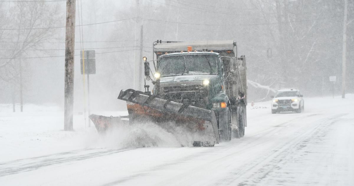
Berkshire County got walloped with fast-falling tiny flakes of snow Sunday that started in the morning around 9 a.m. and didn't stop.
The "expansive winter storm," as the National Weather Service termed it, "continues to bring heavy snow across the lower Great Lakes, interior Northeast and severe icing from the interior Southeast to the Mid-Atlantic through this evening."
In the Berkshires, plow truck drivers were putting in long hours trying to keep up with the snowfall on streets and shaving snow from parking lots.
The state put out over 2,500 pieces of equipment patrolling, spreading and plowing.
Gerry Bergeron, who plows privately in Cheshire and Savoy, estimated that Savoy had 16 inches by nightfall.
He described this particular precipitation as granular, like a heavy cornmeal.
“It’s not easygoing,” he said. “It freezes up fast, the windshield and stuff, when you’re plowing.”
He wasn’t sure how much snow Cheshire got.
A snowplow driver working in Dalton estimated that the town had received a foot by around 6 p.m.
That’s the same amount Trevor Bonadies thought Pittsfield had received by the same time.
“It’s real light snow, which is good, because it’s easier to push around and stack up, so we’re making quick work of it so far,” he said. “Hopefully, we don’t have too much more to go.”
But the worst was yet to come, according to the Massachusetts Department of Transportation.
“Heads up for Sunday evening into early Monday,” it warned in a social media post, referring to the hours of 7 p.m. to 2 a.m. “The heaviest snow is expected during this window, with possibly rapidly deteriorating road conditions. With heavy snow and extreme cold, please limit travel if you can and give crews space to work.”
MassDOT issued reminders about how to drive safely when near snowplows, including the key admonition of never passing a snowplow on the right, with an illustration showing snow pushed to that side of the plow, and advising staying 200 feet behind snowplows because a driver’s field of vision is restricted.
In addition, it advised driving slowly with extra caution to prepare for sudden stops.
On Friday, New York Gov. Kathy Hochul declared a disaster emergency across the state. That same day, Massachusetts Gov. Maura Healey directed non-emergency Executive Department state employees to not report to work. On Sunday, she held a press conference in the afternoon.
“This is the biggest storm we’ve seen in years,” Healey said. “It’s wicked cold already. We’re going to have massive amounts of snow over the next three, four hours. Visibility is going to be terrible. Stay off the roads and check in on your neighbors, and again, for firefighters, make sure you go out and check out those hydrants right around you.”
The Adams Fire Department advises digging out a 3-inch radius around hydrants.
Healey advised taking it easy when shoveling.
“We know this is a time when we can see more cardiac issues,” she said.
At about 11 a.m. on Sunday, the MassDOT lowered the speed limit on the Massachusetts Turnpike to 40 mph in the Berkshires — from the New York state line to mile marker 59 in the Hampden County town of Ludlow. Trucks with tandem trailers were not allowed to be on that part of the road, nor were recreational vehicles, box trucks, tractor-trailers and tankers.
Later, MassDOT extended those restrictions by another 61 miles east to mile marker 110 in Southborough. Those restrictions remain in effect until noon on Monday.
The National Weather Service predicted 6 to 10 inches of accumulation Sunday night, beyond what stacked up during the day as well as an additional 1 to 3 inches of accumulation on Monday.
While highs on Monday could reach 21, lows Monday night were expected to be around 1 degree, with wind chill values as cold as minus 12.
After the main accumulation of Sunday and Monday during the day, there's more to come Monday night in snow showers until 10 p.m. with accumulation of less than half an inch.
Tuesday's prediction is partly sunny with a high near 16 but wind chill values of minus 16.
Read the Original Article
This article was originally published by Berkshire Eagle. Click below to read the full article on their website.
Visit Berkshire Eagle