
The Berkshire route that built a nation: Retracing Henry Knox’s winter march of 1775
Two-hundred fifty years after a 25-year-old Boston bookseller named Henry Knox dragged 59 cannons up and over the Berkshire Hills in the dead of winter, one question still intrigues historians: Exactly which way did he go?
Under orders from Gen. George Washington, Knox and his crew delivered the 60 tons of artillery 300 miles, from Fort Ticonderoga at the southern end of Lake Champlain to the outskirts of Boston, in just 56 days.
The artillery was exactly what Washington, commander of the newly formed Continental Army, needed to drive British forces out of Boston — a pivotal success early in the war for American independence.
Knox’s delivery is made even more astonishing when one considers he and his men made the journey on foot, by directing dozens of draft horses and oxen pulling cannon lashed to handmade sleds, across frozen lakes and rivers, along primitive colonial roads and over the snow-covered Berkshire Hills. The largest cannons were 24-pounders, measuring 11 feet long and weighing 5,000 pounds apiece.
And it’s the precise route Knox and his men followed through the rugged Berkshire Hills — the most difficult leg of the journey — that remains a subject of continuing research by local historians.
And while the general route is undisputed — it’s clear the group crossed into Massachusetts in Alford, then went through Egremont, Great Barrington, Monterey, Sandisfield and Otis, generally following what is Route 71 today — the exact path of Knox’s expedition through the Berkshires continues to intrigue researchers who are still piecing together clues from journals, surveys and long-shifting roads.
Why does getting the route right matter, still, 250 years later?
To Gary Leveille, a local historian who lives in Lee and who has researched the route, called this feat “miraculous.” And therefore, “it seems important to me to understand which way he went,” Leveille said.
Had the mission failed, the British may not have been driven from Boston, making the prospect of independence — and perhaps of the United States of America itself — even less likely.
Knox and his “train of artillery” pulled away from Fort Ticonderoga on Dec. 5, 1775, and headed south past Albany until reaching Kinderhook, N.Y., where it then turned east toward the sparsely populated Berkshire Hills.
Traversing the Berkshire Hills in winter was the most arduous, rugged part of the journey. Knox wrote about it twice in his journal. He was awestruck by the terrain.
On Jan. 10, 1776, Knox wrote: “Reached [No. 1]” — the area that is now the town of Monterey — “after have climb'd mountains from which we might almost have seen all the Kingdoms of the Earth.”
The following day, Knox wrote a little more: “Went 12 miles thro' the Green Woods” — now Sandisfield and Otis — “to Blanford.”
He continued: “It appear'd to me almost a miracle that people with heavy loads should be able to get up & down such hills as are here with any thing of heavy loads.”
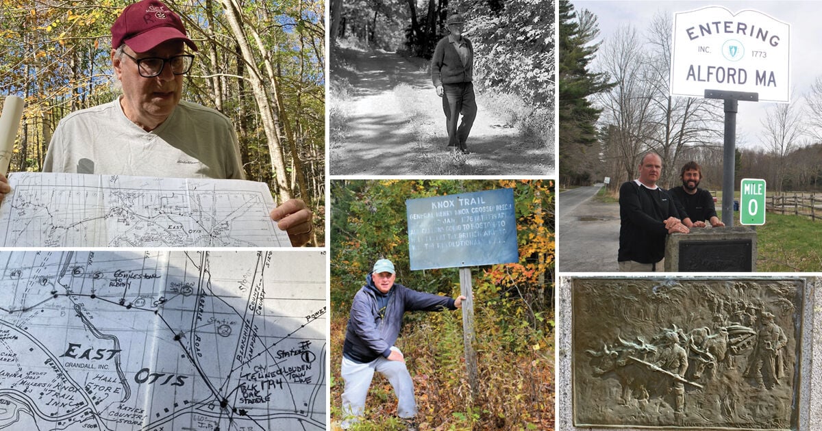
This marker in Otis sits near the actual Knox Trail. That can't be said for all of the historic markers, though, according to local historians.
Jonathan Lane, executive director of Revolution 250 — a Boston-based group of historians dedicated to celebrating Massachusetts’ role in the American Revolution — said that in the 18th century, traveling by water was generally much easier than traveling by land.
“And so we forget that topography and land is a character in this story,” Lane said.
Knox did not map his exact route. But starting in the 1920s, efforts by a committee of New York and Massachusetts members were made to honor history by marking what has become to be known as The Henry Knox Trail. In 1925, their work resulted in historical markers being placed along the Knox Trail.
But questions arose as to how accurate the route was as it approached and went through the Berkshires.
In 1936, Joseph Elliott, then-owner of the North Egremont Country Store and the town’s postmaster, may have been the first to challenge the placement of some of those markers.
Joe Elliott walking on General Knox Lane in North Egremont in 1972.
Elliott grew up in nearby Hillsdale, N.Y., where the Knox expedition came through, and he developed a fascination for its history.
Elliott “realized that something didn’t make sense where the markers were placed,” said Leveille. In recent years, Leveille has retraced Elliott’s footsteps in conducting his own research of the Knox trail.
Leveille said Elliott “did years of research” and shared that with “the authorities in New York state, who realized he was right” about where the trail actually went.
Elliott didn’t live to see the fruits of his research. He died in 1972, three years before markers were resituated and in time for a 200th anniversary reenactment of the Knox expedition.
One marker, which had been placed near what is now the Catamount Mountain Resort on the New York-Massachusetts border, was moved north to the state line at Alford.
Another marker, in the center of Hillsdale, N.Y., was moved to the intersection of U.S. Route 22 and Nobletown Road in Green River, N.Y. A third marker, in Claverack, N.Y., was moved to the intersection of Taconic State Parkway and Harlemville Road in Ghent, N.Y.
Leveille has walked six possible routes and rated them — for their likelihood as possible Knox Trail routes — for his book “Eye of Shawenon: A Berkshire History of North Egremont, Prospect Lake, and the Green River Valley.” Leveille’s research confirms Elliott’s earlier work.
Gary Leveille standing with a vintage Knox Trail sign on North Beech Plain Road in Sandisfield.
Elliott measured the mileage from Knox’s diaries, talked with local residents and hiked the routes.
Leveille said part of the expedition’s path went from Kinderhook to Ghent.
“So they were able to figure out where that original trail was that went from Ghent, over what I call Lookout Mountain, into North Hillsdale, through Green River (a town in New York), and then through Alford and Egremont into Great Barrington.”
In the Berkshires, parts of the actual route Knox and his teams used were later paved. But the whole of Route 23 running between Great Barrington and Monterey — named the Knox Trail in 1927 as a motoring route — does not trace Knox’s exact route through those towns.
Knox’s path through Monterey is a bit of a puzzle.
There are two possible routes through town, said Robert Hoogs, president of the Monterey Historical Society.
One is basically the present Route 23, a route that existed in 1775, Hoogs said.
The other is Brett Road, Beartown Mountain Road and Hupi Road, which is Hoogs’ preference.
“That is the original main road,” Hoogs said. “It isn’t the main route today, but it was the main route in the 1750s, ’60s, ’70s. It's also possible that they split up and followed different routes through town. So that's speculation, not only on my part, but some others’.”
Hoogs said it’s also possible that Knox took a different route from his teams.
“First of all, Knox's journal is about what he was doing,” Hoogs said. “He wasn't necessarily traveling with the cannons at all times. In some cases, he was behind planning for things or making arrangements. He had stayed behind in the Albany area and then caught up to the cannons in Blandford.”
“The general outline of the story is written, but there were very few personal records or newspaper reports or anything of that period,” Hoogs said.
Hoogs has studied Knox’s route through his town, but no artifacts have surfaced. “Certainly not in Monterey,” Hoogs said.
And as to the occasional discovery of a cannonball?
“It's unlikely that those came from Knox because he didn't transport any cannonballs,” Hoogs said. Knox documented everything he brought from Fort Ticonderoga and cannonballs were not among the items.
What would the few people living here in the Berkshire Hills have seen as Knox’s team passed through?
No local newspapers existed in the southern Berkshires at the time, Hoogs said.
Coverage of Henry Knox’s expedition appeared only in brief mentions from papers in Albany and Springfield once he reached those areas.
“But whether they deliberately kept trying to keep it secret? It makes some sense that they might have,” he said. “But how do you disguise or hide an army of several hundred people coming through with sleds hauling 59 cannons?”
It would have been difficult, Hoogs said.
“There were certainly loyalists along the route that would have noticed this and perhaps passed the word along,” Hoogs said. “But it seemed to have caught the British by a little bit of surprise by the time it got to Boston.”
What would Knox’s team see as they passed through the Berkshires?
Not many people or buildings.
The southern Berkshires were “sparsely populated,” said Bernard Drew, historian and author of “Henry Knox and the Revolutionary War Trail in Western Massachusetts.”
Great Barrington had just broken off from Sheffield and was designated the county seat. Great Barrington’s population was just 950, Drew said.
“There were white settlers coming from New York state and white settlers coming from the Westfield area — some of them to farm, some of them to speculate in real estate,” Drew said.
In Alford and Egremont, the actual route wove along and near the present Route 71, Drew said. In Great Barrington, the path generally follows Main Street through the center of town.
Drew, who lives in Great Barrington, knows of a few buildings on Great Barrington’s Main Street dating to Knox’s time, one being a saltbox house with fancy trim, the Joseph Dwight house at 380 Main St., now a law office.
He believes that, in Great Barrington, Knox’s troops crossed the Housatonic River on a wooden bridge where the current bridge carrying State Road (Route 7) now stands, then cut through the cemetery past the first meetinghouse to continue east.
Bernard Drew believes the Knox Trail crossed in front of Great Barrington's first meetinghouse in what is now a cemetery.
Tom Ragusa, an Otis resident and Knox Trail historian who has studied the route comprehensively, relied on a 1764 survey by Sheffield resident Nathaniel Austin to map the route that he believes Knox took through Otis and Sandisfield.
Tom Ragusa demonstrates how he traced 7 miles of the Knox Trail through Otis and Sandisfield.
First, he had to find the survey, which was on file with the Massachusetts Supreme Judicial Court archives in Boston. It took a researcher there two months to unearth it.
He first learned of the survey when researching a different project and found a reference to it in the Middle Berkshire Registry of Deeds.
Once Ragusa had that, he studied and updated compass readings taken in 1764 to match modern bearings in order to stay on track.
Tom Ragusa holds the compass he used to map the Knox Trail through Otis and Sandisfield.
Tom Ragusa has mapped 7 miles of the Knox Trail. This is a detail from his paper map.
Ragusa began his work at Otis State Forest near Twenty-Five Mile River, a brook Austin mentioned in his survey. Ragusa then worked his way west.
Over three years, Ragusa mapped 7 miles running through Otis and Sandisfield. And he took his 7 miles of work — which he initially drew in black pen on a paper map — and translated it on a 15-foot-long map.
All of his work is now on file with the Massachusetts Historical Commission’s mapping system.
“The hardest part was converting old numbers to modern numbers,” Ragusa said. “A lot of marked trees that are gone. The only thing I really had was rocks and boulders that are still around that haven’t been disturbed.”
Tom Ragusa holds the paper map he used to trace the route of the Knox Trail in Otis and Sandisfield.
Ragusa used a protractor rotator to plot the magnetic declination and to plot the directions on the paper map. He also converted distances from rods — on the original survey — to feet. A rod contains 16.5 feet.
He knows some rocks haven’t been disturbed based on their size.
“Because they’re big,” he said.
Based on Ragusa’s research, Otis Highway Department workers on Monday placed new Knox Trail markers at two locations in Otis, at mile markers 58 and 64 from Albany. The 64-mile marker in East Otis on Norton Road reads, “64 m to Albany.” The 58-mile marker is on Cold Spring Road in West Otis.
Otis Highway Department workers set the 64-mile post marker from Albany along the section of the Knox Trail that Tom Ragusa mapped.
Ron Bernard, a local historian and chair of Sandisfield’s Historical Commission, credits Ragusa for his work.
The 65-mile marker from Albany, N.Y., that Tom Ragusa found on the Knox Trail in Otis.
The Sandisfield section of the Knox Trail runs through Otis State Forest.
“It’s the longest, original section in 300 miles,” Bernard said. “And in a sense, it is a window in what the trail might have looked like through most of its path.”
Ragusa would like to see Sandisfield get an official marker since the Knox Trail crossed into it. He also hopes to get national recognition for the actual route — or routes — Knox and his teams took.
“It goes back to the Native Americans,” he said. “It’s been used by thousands of people.”
But given that Knox’s expedition was carried out in relative secrecy, that may never be known.
“As I like to say, none of us were ever there,” Leveille said.
Read the Original Article
This article was originally published by Berkshire Eagle. Click below to read the full article on their website.
Visit Berkshire Eagle