
Arctic Cold & Major Snowstorm on the Way for the Weekend
SPRINGFIELD, Mass. (WGGB/WSHM) - It was a cold start this morning, definitely colder than Thursday morning.
Today will feature a mix of sun and clouds with highs in the upper 20’s and lower 30’s. Breezy today, so wind chills may range in the teens and 20’s. Perhaps a few flurries or off and on snow showers this afternoon.
Tonight, and tomorrow morning the bitter cold sets in.
**Cold Weather Advisory in effect from Friday 10 pm to 10 am Saturday morning for Central and Eastern Hampden, Hampshire & Franklin Counties**
**Extreme Cold Warning in effect from Friday 7 pm to Saturday 1 pm for Berkshire County and Western Hampden, Hampshire, Franklin Counties**
First thing on Saturday morning, temperatures will be on either side of 0°. A gusty breeze will put wind chills between -10 to -30°. Very dangerous cold.
The bitter cold continues all weekend, but it will be at its worst on Saturday morning. On top of this cold through, we have a major snowstorm on the way too.
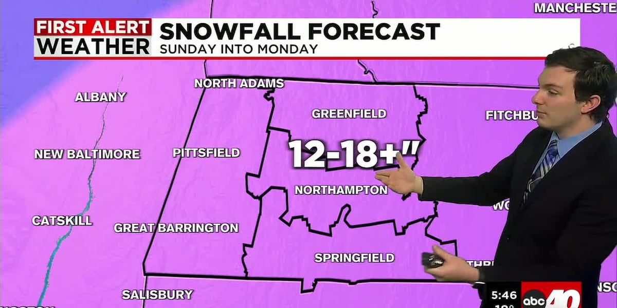
**Winter Storm Watch in effect from 7 am Sunday through 7 pm Monday for all of western Mass**
Low pressure travels across the country, bringing snow and freezing rain to parts of the south. As low pressure moves offshore, snow heads our way.
Snow begins around midday on Sunday, and lasts for the rest of the day, into Sunday night. Ending by mid to late day on Monday.
With how cold it will be, the snow will be light and fluffy, so it piles up quickly. We’ll likely see at least a foot of snow for all of Western Mass, with some areas picking up close to 18 inches to 2 feet.
After snow ends, the cold sticks around. Most of next week will continue to feature below normal temperatures. Overnight lows in the single digits to around 0°, with daytime highs in the teens and 20’s.
Copyright 2026 Western Mass News (WGGB/WSHM). All rights reserved.
Read the Original Article
This article was originally published by Western Mass News. Click below to read the full article on their website.
Visit Western Mass News