
Bright & Warm to Start the Week
SPRINGFIELD, Mass. (WGGB/WSHM) - After a stretch of classic-June temperatures, we’re turning up the heat for this week. Treat Monday and Tuesday as preview, or transition days into the extreme heat, which starts Wednesday.
Today, we’re mostly sunny and warm with highs ranging in the middle and upper 80’s to around 90°. Dew points are in the lower 60’s, so it will also feel a little muggy, but humidity today will not be off the charts.
Tonight, we’re mostly clear and cool with lows falling into the upper 50’s and lower 60’s.
Tuesday, we’re partly sunny, hot and more humid. Highs will range in the upper 80’s and lower 90’s once again, though dew points in the upper 60’s will make it feel more humid. We also run the risk for a late-day shower or storm.
Starting Wednesday, we have extreme heat on the way. A dome of high pressure will set up over the Eastern U.S. this week sending the Jetstream well into Canada.
For context, our normal high temperatures should be between 83-84° for the Springfield area.
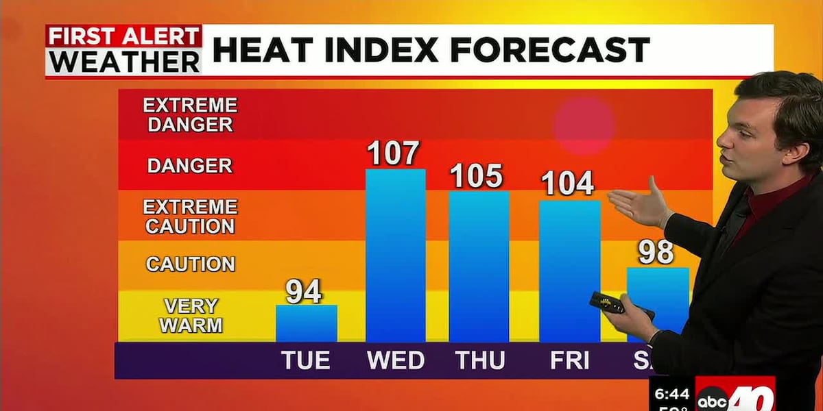
**An Extreme Heat Watch is in effect for Hampden, Hampshire and Franklin Counties Wednesday through Friday**
Wednesday, Thursday and Friday are all First Alert Weather Days due to this extreme heat. We’re talking high temperatures between 95-100° all three days. Very high humidity with dew points between 70-75°. This combination drives feels-like temperatures, or heat index values to 105°+.
Long term exposure to this level of heat will likely lead to heat-related illness. Limit your time outside and make sure you are drinking tons of water to stay hydrated. UV index will also range between 8-10 each day as well, so you can get sun burnt very fast.
Each day will otherwise feature mostly sunny skies. Wednesday, we may see the chance for a late-day shower or storm.
4th of July weekend is also looking very hot as well. We may end up extending the First Alert Weather Days to include the weekend. Highs will range both days in the middle and upper 90’s with continued high humidity. Bringing feels-like temperatures into the triple digits. We may also run the risk for a late-day shower or storm both days.
Next week, we look to see this extreme heat break down, and temperatures return closer to normal.
Copyright 2026 Western Mass News (WGGB/WSHM). All rights reserved.
Read the Original Article
This article was originally published by Western Mass News. Click below to read the full article on their website.
Visit Western Mass News