
Light Snow Tuesday May Bring a White Christmas
SPRINGFIELD, Mass. (WGGB/WSHM) - A weak clipper system will bring periods of light snow with minor accumulations today.
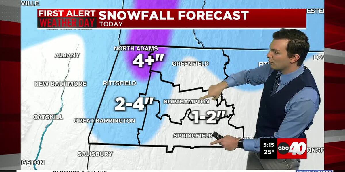
**A Winter Weather Advisory is in effect for Berkshire County from 7am Tuesday through 7am Wednesday**
Snow begins between 7-9 am today and lasts all day. Coming to an end between 5-7pm.
We’re looking at about 1-2 inches of snow in the Pioneer valley. Some slightly elevated areas might get close to 3 inches. Then the higher in elevation you go, the hill towns and Berkshire’s, we’re likely to see around 2-4 inches of snow. Isolated amounts over 4 inches in locations over 1,500′ in elevation.
Tonight, skies gradually clear and winds increase as low pressure moves offshore. Lows fall into the 20’s to around 30°.
Christmas eve is tomorrow, and we’ll see mostly sunny skies with highs between 32-40°, with a gusty wind out of the northwest. Gusting between 25-35 mph at times. Wind chills range in the lower 30’s.
Christmas Day will feature more clouds around, but we remain dry with less of a breeze. Highs between 34-40°.
While temperatures do get above freezing Christmas eve and Christmas Day, hopefully we don’t see too much melting from Tuesday’s snow to leave ourselves with a white Christmas. Likely a white Christmas in the hills, and hopefully still some snow is left on the ground for us in the valley. Looking pretty good.
We’re tracking the chance for a few more snow showers perhaps late Friday into Saturday. Then another around of rain and snow showers for Sunday.
Next week, the final few days of 2025 are looking dry and chilly.
Copyright 2025. Western Mass News (WGGB/WSHM). All rights reserved.
Read the Original Article
This article was originally published by Western Mass News. Click below to read the full article on their website.
Visit Western Mass News