
One More Hot Day Wednesday Before Relief Comes in
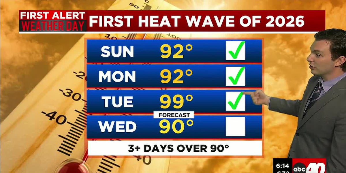
SPRINGFIELD, Mass. (WGGB/WSHM) - What a hot day Tuesday! We got to 99° at Westover in Chicopee, shattering the previous record of 92°. We were 97° at Barnes in Westfield.
Today is another hot day, making it a First Alert Weather Day.
**Heat Advisories remain in effect through 8pm this evening for Central and Eastern Hampden, Hampshire, Franklin Counties.**
Temperatures likely reaching 90° once again. It’s also humid, driving feels-like temperatures into the low and mid-90’s.
A cold front coming through later in the day will bring the risk for some downpours and isolated thunderstorms. This would be between 12-4pm.
Once we get behind this cold front, dew points crash, and temperatures return closer to where they should be for May for the remainder of the week.
Our front lingers to the south with low pressure forming along the front. Clouds build in overnight tonight with the chance for a few showers by early Thursday morning, especially along and south of the Mass Pike.
Thursday, we’re mostly cloudy with rain mostly to our south, aside from a few showers in the morning. Highs are much cooler, ranging in the middle and upper 60’s to near 70°.
Friday, the nicest day of the whole week. We’re mostly sunny with low humidity, and highs in the upper 60’s and low to mid-70’s.
Memorial Day weekend right now looks unsettled and cool with highs in the 60’s, as well as mainly cloudy with some spotty showers.
Copyright 2026 Western Mass News (WGGB/WSHM). All rights reserved.
Read the Original Article
This article was originally published by Western Mass News. Click below to read the full article on their website.
Visit Western Mass News