
Strong to Severe Storms Likely Thursday
SPRINGFIELD, Mass. (WGGB/WSHM) - We had a warm, muggy and damp start to our day after a warm front with spotty showers came through overnight.
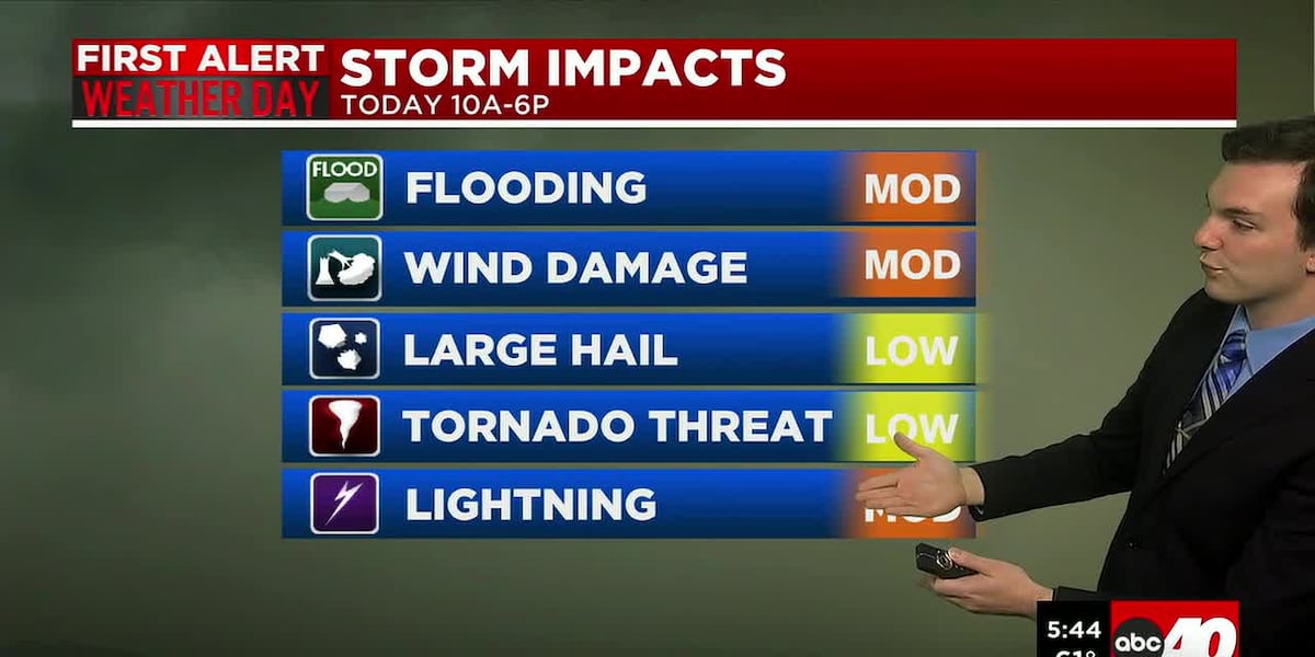
Today is a First Alert Weather Day.
It’s warm and humid. We’ll have spotty showers around in the morning. Then, a cold front approaches, and ahead of that front, we will see some rain, downpours and some thunderstorms with gusty winds.
Main concerns would be downed trees and power outages from damaging winds, flash flooding from downpours, and we can’t rule out the risk for an isolated weak tornado.
We may see a few non-severe thunderstorms between 10am and noon. Some breaks of sun, which would fuel more instability in the atmosphere, allowing for more storm development. Then between 1-6pm, strong to severe storms roll through ahead of our front.
The storm prediction center places Western Mass under a slight risk for severe weather, 2 out of 5 on the scale, with a 2-5% risk for a tornado. The risk is low, but not zero, so we must be prepared.
Behind the front, we turn less humid and we’re drying out tonight. Lows fall to either side of 60°.
Friday, Juneteenth, is drier, less humid and breezy under a mix of sun and clouds. Low pressure lingering in Eastern Canada, along with a strong northwesterly breeze could bring a spot shower Friday and Saturday, but the majority of the days are dry.
This weekend right now is also looking nice. Partly to mostly sunny both Saturday and Sunday. Highs in the upper 70’s to around 80°. Windy at times, especially Saturday. Sunday by the way is the first day of Summer and Father’s Day!
Next week looks to start muggy, and rainy, then drying out as the week goes on.
Copyright 2026 Western Mass News (WGGB/WSHM). All rights reserved.
Read the Original Article
This article was originally published by Western Mass News. Click below to read the full article on their website.
Visit Western Mass News