
Sunny & Hot Through the End of the Week
SPRINGFIELD, Mass. (WGGB/WSHM) - We had a nice, cool start to our day, but temperatures rise fast, and it’s hot again for today. We could be entering our second heat wave of the year.
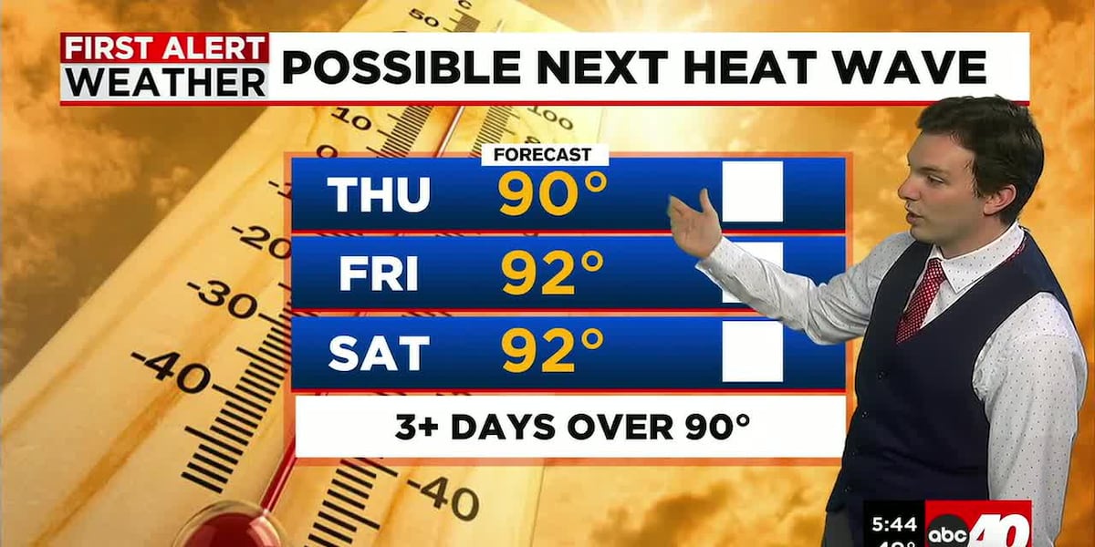
High pressure is still in control of our weather, so we will see mostly sunny skies and a very light breeze. Highs in the Valley will range in the upper 80’s to around 90°, low to mid-80’s for the higher elevations.
While it is going to be hot, dew points remain in the 40’s, so the humidity is low, making the heat a little more manageable.
Tonight, it’s cool and refreshing with lows falling into the 50’s under mostly clear skies.
Friday remains bright and hot. Highs in the upper 80’s and lower 90’s. Humidity also remains low.
Saturday is looking partly sunny, hot and getting muggier ahead of a cold front. Highs in the upper-80’s to low-90’s. Many hours of the day features sun and clouds. Isolated pop-up downpours in the afternoon ahead of our front.
Then as we move into the evening, downpours and thunderstorms roll through. Some of these storms could be on the strong to severe side. The storm prediction center places all of Western Massachusetts under a marginal risk for severe weather, 1 out of 5 on the scale, already 3 days out.
As the front slowly pulls away, leftover showers may linger around for Sunday. It’s also muggy as the front is passing, especially in the morning, then turning less humid with highs in the 70’s to around 80°.
Next week is trending seasonable and dry. Daytime highs ranging in the upper 70’s and low to mid-80’s. Perhaps a stretch in the 90’s once again towards the end of the week. Maybe even another heat wave directly following the one for this week.
Copyright 2026 Western Mass News (WGGB/WSHM). All rights reserved.
Read the Original Article
This article was originally published by Western Mass News. Click below to read the full article on their website.
Visit Western Mass News