
Sunny & Hot to Start the Week
SPRINGFIELD, Mass. (WGGB/WSHM) - After a warm and sunny weekend, our dry and warm trend continues into this week.
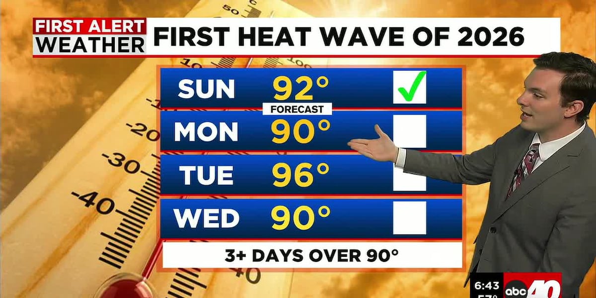
We also may be in the midst of our first heat wave of the season. We got to 92° Sunday in Springfield, and if we get 3 or more days in a row of 90+°, it will be a heatwave!
Today, we’re mostly sunny and hot with highs approaching 90°. UV Index will be an 8, so make sure you have sunscreen, sunglasses, and you are staying hydrated. Humidity today remains relatively low.
Tonight, we’re mostly clear, mild, and a bit muggier as dew points start to climb. Tonight lows only fall into the middle 60’s. As we wake up Tuesday, we’ll have that mild, muggy feel.
Tuesday will be a First Alert Weather Day.
Tuesday will be very hot and humid. Highs are expected to range in the middle and upper 90’s. Higher humidity bringing feels-like temperatures to near triple digits. It’s also mainly sunny for the majority of the day.
Between 3-6pm, we have a chance for a few downpours to roll through with a few embedded strong thunderstorms too.
Wednesday may also be a First Alert Weather Day.
This is as temperatures remain hot in the afternoon, likely reaching 90° once again. It will also be more humid, driving feels-like temperatures into the middle 90’s.
A cold front coming through later in the day will bring the risk for some downpours and strong to severe thunderstorms too.
Once we get behind this cold front, dew points crash, and temperatures return closer to where they should be for May for the remainder of the week. Highs Thursday and Friday will range in the lower 70’s.
Copyright 2026 Western Mass News (WGGB/WSHM). All rights reserved.
Read the Original Article
This article was originally published by Western Mass News. Click below to read the full article on their website.
Visit Western Mass News